
The new 6-lane elevated road project on the Strategic Periphery Road (SPR) in the city’s southern corridor is set to reshape connectivity and.infrastructure in Gurugram.
Dateline: Gurugram | 18 November 2025
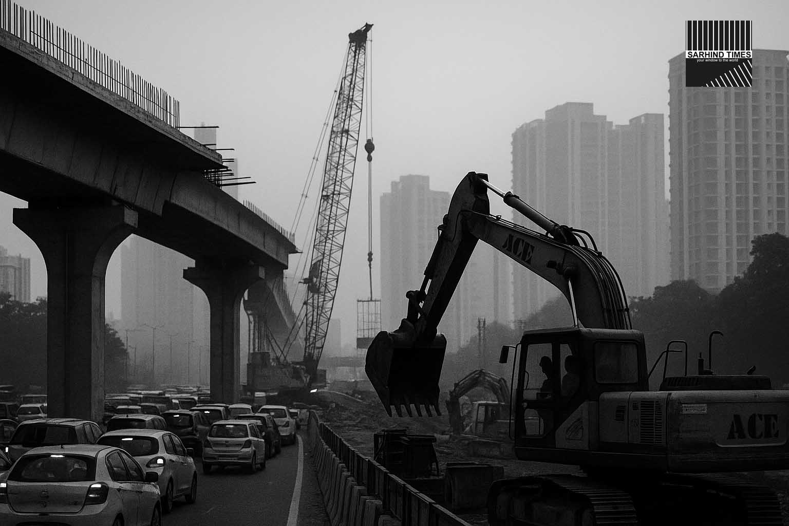
Summary: The Gurugram Metropolitan Development Authority (GMDA) has approved a major elevated corridor project linking Vatika Chowk with Ghata Chowk along the SPR stretch in Gurugram. The six-lane carriageway with accompanying service roads and fly-overs is designed to tackle chronic traffic gridlock and water-logging in this high-growth urban zone. While the plan promises relief for commuters and neighbourhoods alike, experts say execution, coordination and environmental integration will determine whether it really becomes the game-changer the region expects.
Background: Why this corridor matters
Located in the southern sectors of Gurugram, the Strategic Periphery Road (SPR) zone has seen rapid residential and commercial expansion over the last decade. As sectors such as 67, 68, 75, 79 and beyond have grown, traffic flows from the city core towards the highway belt, corporate parks and Dwarka-Expressway corridor have intensified. At the same time, repeated rainfall episodes have highlighted the inadequate infrastructure of the existing at-grade roads, where under-passes flood, service roads choke and connectivity drops severely during monsoon hours.
The elevated corridor between Vatika Chowk and Ghata Chowk is now viewed as a critical mitigation measure. According to GMDA officials, the elevated portion will segregate through-traffic from local traffic, remove multiple signal-intersections, and integrate improved drainage underneath the structure. In 2022, GMDA had already proposed widening the road into six lanes with three-lane service roads and eight fly-overs at key intersections. The new development formalises this as an elevated corridor rather than a conventional widening project.
For commuters, the benefits are clear in principle: faster travel, fewer bottlenecks, less exposure to flooding, and potential uplift in real-estate and commercial viability. But the success hinges on land acquisition, engineering design, storm-water integration, and timeline delivery.
Key features of the project
The elevated corridor project has several defining features:
– The main carriageway will consist of **six lanes**, elevated above the current road level, to bypass congested intersections between Vatika Chowk and Ghata Chowk.
– Beneath the elevated lanes will run service roads (three-lane each side) catering to local traffic, township entry/exit, and commercial access — helping separate local from through traffic.
– Eight major fly-overs are planned at key cross-junctions to eliminate signal delays and protect traffic flow from interruptions.
– The design incorporates enhanced storm-water drainage underneath and alongside the elevated platform, aiming to reduce water-logging risk in heavy rainfall events. GMDA officials have emphasised the dual objective of mobility + flood alleviation.
– The project alignment passes through high-density sectors, corporate parks and residential townships; it will also intersect feeder roads leading towards Dwarka Expressway, the express highway belt and service corridors, thereby improving overall connectivity.
– According to GMDA, the project will be executed in phases — first clearing the alignment and land parcels, then beginning piling and elevated structure construction, followed by overlay and service-road integration.
Projected benefits: mobility, reliability and urban resilience
If delivered on schedule and quality, the corridor is expected to bring meaningful changes:
– **Reduced congestion**: The current stretch between Vatika and Ghata is a known pain-zone for commuters, especially during peak hours when the existing at-grade road merges multiple township access roads, service lanes and highway feeders. The elevated design promises smoother corridor movement.
– **Shorter travel times**: GMDA projects that travel time along the corridor could drop by up to 30-40 per cent during peak hours, and the elevated structure will reduce risk of traffic jams caused by rain-induced flooding of surface lanes.
– **Less flood-vulnerability**: By raising the main carriageway and improving drainage underneath, the project aims to keep through-traffic moving even when surface roads are inundated. This is important given the recurring water-logging on SPR segments during monsoon.
– **Real-estate and commercial uplift**: Reliable connectivity is a major factor in real-estate valuations. With improved road infrastructure, sectors adjacent to the corridor are expected to attract further investment, higher occupancy, better corporate leasing and improved township marketability.
– **Safety and comfort**: Elevated carriageways typically reduce conflict points, pedestrian-interactions, and mixed traffic issues. For a growing city like Gurugram where vehicle density, two-wheelers, cabs and trucks share space, the separation is meaningful.
– **Urban resilience and growth readiness**: As the Dwarka Expressway, commercial hubs and new townships extend southwards, infrastructure like this corridor becomes foundational rather than optional. It positions the city to absorb future growth with less friction.
Land-and-logistics challenges ahead
Notwithstanding the benefits, major execution risks remain. Analysts point to:
– **Land acquisition and litigation**: Although the alignment mostly passes through government land and planned townships, some parcels still involve private holdings and village lands along Khandsa–Mohammadpur Jharsa belts. Securing clear rights of way and resolving disputes can delay progress. GMDA earlier flagged this in its 2022 widening proposal.
– **Engineering complexity**: Building elevated structures in densely built zones with active traffic diversion, service-road continuity, utility shifts (sewer, telecom, power lines) and stakeholder coordination (townships, corporates, truck routes) places operational strain. Quality assurance, worker safety and minimal disruption will be challenging.
– **Traffic management during construction**: For the corridor to succeed, mitigating interim construction-traffic disruption is critical. Residents and commuters are sceptical about months of chaos leading to long-term benefit. Township security and corporate commuter systems will be stressed.
– **Drainage integration and climate adaptation**: The corridor’s dual objective of mobility + flood-resilience will test execution teams. Ensuring that the drainage systems under the elevated road operate effectively in heavy rainfall — and don’t become choke-points themselves — will require close design monitoring, maintenance and future upgrades.
– **Cost escalation and maintenance burden**: Elevated roads cost significantly more than at-grade widening. Maintenance of elevated structure, bearings, periodic inspection, lighting, drainage cleaning and monitoring adds to lifecycle costs. Township managers, GMDA and state agencies must budget accordingly.
– **Coordination with multiple stakeholders**: Given the corridor’s intersection with residential societies, corporate parks (e.g., Vatika, DLF, etc), utilities, and service-roads, aligning stakeholder interests, communication protocols and construction timelines will be critical to minimise friction and leverage synergies.
Stakeholder perspectives: corporates, residents, local government
– **Residents and HOAs**: For residents of sectors along the corridor, this is a welcome development — especially because they face daily commute pain, frequent under-pass flooding, and road-safety concerns. Many township residents say past infrastructure promises have been delayed, so their optimism is cautious. They highlight the need for regular stakeholder-briefings, construction updates and interim mitigation (e.g., dust-control, diversion lanes, lighting).
– **Corporate campuses and logistics hubs**: Corporate offices near Vatika, Ghata and SPR express concern about traffic unpredictability, employee commute disruptions and shift-guardianship. The elevated corridor, if executed well, offers a corridor buffer and reliable access. Logistics operators meanwhile appreciate the ability to segregate through freight traffic from township access.
– **GMDA & state government**: Officials at GMDA view this project as a key lever to de-congest south-Gurugram, prepare growth corridors and build infrastructure for the next decade. It aligns with the state’s ambition of “smart-city” readiness, high-quality infrastructure and flood-resilient design. They emphasise timelines and have flagged mid-2028 for substantial completion (subject to clearances).
– **Urban-planning and infrastructure analysts**: These experts caution that the corridor must integrate with wider mobility networks: last-mile connections, public-transport links, pedestrian/cyclist lanes and feeder roads. Elevated roads alone cannot solve congestion without an ecosystem. They also urge transparency around funding, tolling or public-private models, and maintenance guarantees.
Implementation timeline and investment details
According to GMDA disclosures, the project has the following broad timeline:
– Land-clearance and alignment locking: Q4 2025 to Q2 2026.
– Piling and elevated-pier construction: Q3 2026 to Q4 2027.
– Super-structure erection, service roads and fly-over integration: Q1 2028 to Q4 2028.
– Final testing, public access and commissioning: Late 2028.
The estimated project cost is in the range of ₹2,200-2,400 crore (indicative), subject to detailed design, inflation, relocation costs and utility shifts. Funding is via GMDA/state-budget allocations, with a possibility of private partner engagement for maintenance/operation.
During the construction phase, GMDA has indicated a traffic-management plan will be published, including temporary diversions, night-work scheduling, safety monitoring, information kiosks for residents and frequent updates via digital dashboards.
Risks to monitor and must-do mitigation steps
To maximise chances of success, the following risks must be tracked and mitigated:
– **Land-acquisition delay**: GMDA must expedite litigation-monitoring, fair compensation, transparent land-transfer schedules and continuous coordination with village panchayats, private plot-owners, and township developers.
– **Budget over-run and funding gap**: Escalation risk can derail completion, hence contingency budgeting, staged releases and market mindful procurement must be ensured.
– **Quality assurance and structural integrity**: Elevated roads carry higher safety burden—regular inspection, compliance with seismic/wind-load norms, drainage functionality and public-safety must be non-negotiable.
– **Interim disruption management**: Construction must try to minimise impact on existing traffic, township access and corporate commuters. GMDA should provide frequent updates, signage, alternate routes and ensure night-work doesn’t escalate noise/air pollution for residents.
– **Drainage and flooding redundancy**: Given the region’s vulnerability to heavy rain, the new design must include excess-runoff diversion, periodic cleaning of service-road drains, monitoring of under-pass flooding scenarios and backup pump-plans.
– **Future-proofing and public transport linkage**: Elevated corridor must integrate with upcoming metro, RRTS or rapid-bus-transit systems. Without feeder links and multi-modal integration, elevated roads may again suffer bottlenecks as traffic grows.
– **Community engagement and oversight**: Resident groups must be engaged in construction monitoring, complaints resolution, quality audits and ensuring that promises (noise-barriers, landscaping, lighting) are delivered, not delayed.
What to watch over the next 12 months
The near term will provide early signals of momentum:
– Whether GMDA issues the Request for Proposals (RFP) for detailed design and construction by mid-2026.
– Whether land-acquisition notices are served, compensation schemes launched and contested plots settled by Q2 2026.
– Whether construction-mobilisation begins (cranes, piling rigs, temporary traffic diversions) by late 2026, signalling the project is off-paper.
– Whether GMDA publishes a traffic-management plan for commuters and residents during construction, including alternative route mapping and stakeholder consultation.
– Whether the project obtains necessary environmental clearance, tree-transplantation approvals, utility-relocation sign-offs and storm-water modelling completed.
Success in these milestones will build credibility and maintain investor/resident confidence; delay in any one of these may push the project into “paper promise” territory.
Conclusion: A pivotal corridor—but execution will define legacy
The elevated corridor between Vatika Chowk and Ghata Chowk represents a major leap in Gurugram’s infrastructure journey. By envisaging a six-lane elevated road plus service roads and fly-overs, engineers and city-planners are acknowledging that traditional at-grade expansion alone no longer suffices for fast-growing urban corridors.
For commuters and residents, the promise is appealing—less gridlock, less flooding, improved liveability. For developers and investors, the corridor enhances the attractiveness of adjoining sectors, reinforcing Gurugram’s position as a growth node. For city-planners, it underscores Mumbai-Gurgaon-Delhi scale infrastructure thinking.
Yet this project comes at a moment when infrastructure ambition must be matched by civic integrity, execution discipline and stakeholder transparency. Elevated roads cost more, demand higher standards, and need maintenance regimes built in from day one. Institutional will, financial discipline and community vigilance will be just as critical as engineering.
In the end, this elevated corridor may redefine southern Gurugram’s mobility and growth trajectory — but only if it is delivered on time, integrated smartly, and maintained well. Witnessing its execution will be the city’s test of whether infrastructure promises can turn into operational impact.


+ There are no comments
Add yours