
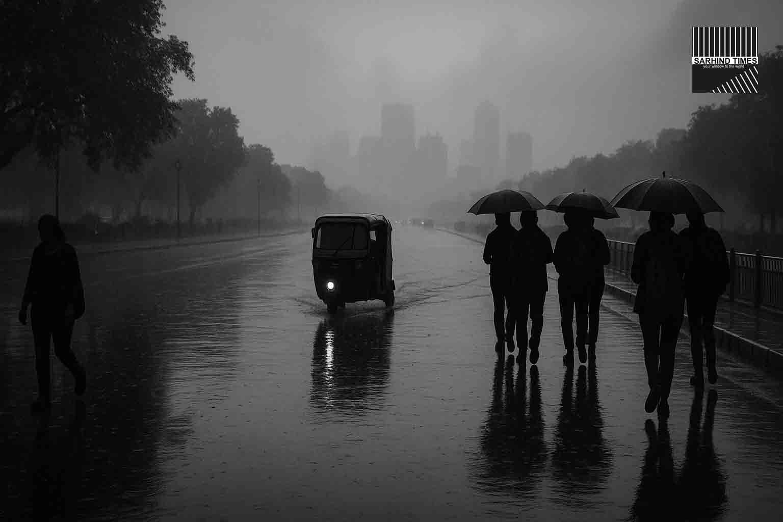
NEW DELHI / NCR – A strong western disturbance sweeping across northwestern India has jolted the weather in the national capital region, unleashing rain, gusty winds, falling temperatures, and travel disruptions across air and road networks. Over the past 24 hours, Delhi-NCR has recorded scattered showers, waterlogging on arterial routes, and reductions in visibility, prompting authorities to issue advisories and airlines to divert flights. As the chill sets in and moisture lingers, city residents are bracing for a spell of cooler days ahead—alongside the logistical ripple effects that sudden weather shifts invariably bring.
The India Meteorological Department (IMD) has flagged the system as a classic western disturbance, aided by upper-level troughs and cyclonic circulations. It forecasts a gradual tapering of rainfall, even as the cooler air mass lingers and night minima dip. But for travellers, commuters, and residents already contending with monsoon fatigue, the sudden transition underscores the importance of weather vigilance and infrastructural readiness.
Below is a comprehensive look: the meteorology, impacts, advisories, response, and what to expect in the coming days.
I. Meteorological Backdrop: What Is a Western Disturbance & Why Now?
A. Anatomy of a Western Disturbance
A western disturbance is a low-pressure system originating in the Mediterranean or Caspian region, traveling eastwards across Afghanistan and Pakistan before influencing northwestern India. These systems often bring winter precipitation (snow in the Himalayas, rain in the plains) and modulate temperature by drawing in colder air masses from higher latitudes.
In the post-monsoon season (October onward), these disturbances can still remain active, especially when supported by additional upper-air dynamics (e.g. cyclonic circulations), moisture influx or convergences. In Delhi’s climate narrative, these intrusions help punctuate the relatively dry post-monsoon interval with sudden showers and cooling.
B. Recent Observations & Rainfall Metrics
Over the past 24 to 48 hours:
- Delhi recorded light to moderate rain across multiple localities, including Palam, Ridge, Safdarjung, and surrounding suburbs.
- Palam (IGI vicinity) reportedly saw 41.6 mm rainfall during peak periods.
- Safdarjung, a key meteorological station, logged 12.6 mm overnight, followed by further precipitation during daytime spells.
- Visibility dropped significantly in certain stretches (e.g. from ~6,000 m in early afternoon to ~1,200 m by evening) at Palam, disrupting visual operations and traffic.
- Temperature highs dipped below seasonal norms: Delhi recorded a maximum of ~26.5 °C, nearly 8 °C lower than typical October values.
- Nighttime lows also showed signs of cooling—with minima hovering around 20–22 °C, and in some zones slightly lower.
These shifts are consistent with the passage of a pre-winter weather system activating cooler northwest winds and cloud cover, which suppress daytime heating and enhance nocturnal radiative cooling.
C. Forecast & Expected Evolution
IMD and local forecasts suggest:
- Rain intensity is expected to taper in the next 24–48 hours, though isolated showers or drizzle may persist in pockets.
- Maximum temperatures may rebound slightly but remain below average, with highs in the mid to upper 20s.
- Minima may trend downward, especially on clear nights, hitting the low 20s or even high teens in peripheral areas.
- Winds from the northwest will persist, sustaining the chill factor and aiding dispersion of pollutants.
- Skies may gradually clear, allowing for better sunshine, but residual humidity and cloud cover may delay full warming cycles.
II. Impacts & Disruptions: Skies, Roads, and Commuter Woes
A. Air Travel: Delays, Diversions & Advisory Warnings
The disruption of flight operations has been among the most tangible consequences of the sudden weather shift:
- As many as 15 flights at Delhi’s Indira Gandhi International Airport (IGI) were diverted owing to poor visibility and saturated runways.
- Airlines issued advisories urging passengers to arrive earlier than usual and monitor flight status continually.
- Because visibility dipped (especially in late afternoon), landings and takeoffs experienced greater holding times, contributing to knock-on delays.
- Some diversions were routed to Jaipur (8), Lucknow (5), and Chandigarh (2), depending on alternate runway availability and fuel considerations.
For travellers, this meant uncertainty, missed connections, and logistical rework—even before considering ground travel to the airport.
B. Road & Urban Mobility: Waterlogging, Congestion & Sluggish Traffic
The capital’s roads bore the brunt of excess water:
- Waterlogging was reported across major stretches—underpasses, arterial roads, service lanes in South, West and Central Delhi
- Traffic snarls followed in key sectors: Barapullah, Mathura Road, Lajpat Nagar, Outer Ring Road, Dwarka Expressway among others faced gridlocks as water reduced speed, blocked lanes, and hampered flow.
- A collision on the Barapullah elevated corridor reportedly caused a 24-meter jam, spilling onto adjacent highways and exacerbating delays heading toward Noida and Gurgaon.
- Motorists reported being stuck for over an hour in short distances, especially during evening peak hours.
- Access routes to the airport also suffered, compounding delays in reaching IGI amid reduced lane availability and congestion.
Commuters, taxis, delivery services and public transport all found their schedules disrupted. For many, what should have been a routine drive turned painstakingly slow.
C. Other Disruptions & Secondary Effects
- Visibility hazards led to cautious driving and slowed speeds even where waterlogging was minimal.
- Public advisory alerts were issued urging vigilance, avoiding non-essential travel during peak wet spells, and caution in underpasses or low-lying zones.
- Air quality, however, briefly benefited: Particulate pollution was washed off, nudging AQI into the “satisfactory” range.
- Some areas experienced intermittent power fluctuations or signaling delays at traffic lights, possibly due to water intrusion or humidity.
- Emergency response units were mobilized to address pothole flooding, drain blockages, and localized flooding complaints.
III. Delhi’s Climate Rhythm & Seasonal Context
A. Post-Monsoon Transition & Climatology
Delhi’s climate is broadly humid subtropical, with a distinct monsoon season (June–September) and a cool dry winter (November to February).
October forms a transitional window—monsoonal withdrawal completes, humidity recedes, and temperatures gradually slide. Western disturbances, more active in winters, sometimes intrude into October, bringing unscheduled rain and cooling.
Recent years have shown Delhi getting unexpected rainfall in October — sometimes forcing rethinking of infrastructure readiness and waterlogging mitigation.
B. Temperature Norms & Deviations
- Historically, October maximums in Delhi hover in the 33–34 °C zone, with minima around 20–22 °C.
- The recorded maximum of 26.5 °C marks a substantial negative deviation—indicative of strong cooling influence.
- On months with rainfall or cloud cover, diurnal ranges compress: daytime gains are muted, nights get cooler.
In this framework, the current weather event is a strong nudge toward early winter taste—more than a routine October rainy patch.
IV. Advisories, Preparedness & Response
A. Official Alerts & Guidance
- IMD issued orange or yellow alerts for Delhi-NCR sectors, especially southwest, west and north zones, warning of moderate rain, thunderstorms, gusty winds and localized flooding.
- Civil aviation, airport authorities and airlines coordinated to issue flight advisories and warnings about arrival/departure delays.
- Traffic police and municipal agencies urged commuters to allow extra time, avoid waterlogged stretches, and exercise caution in low visibility.
- Drainage departments were deployed to clear clog points proactively; pumps and waterworks teams were put on standby.
- Public communications emphasized caution in underpasses, avoiding over-speeding through pooled water, and minimizing nonessential movement during peak rain spells.
B. Civic Response & Mitigation
- Municipal contractors deployed sump pumps, roving water tankers and drain cleaning teams in flood-prone zones.
- Flash flood warnings were sent via mobile alert systems in susceptible localities.
- Public transport (buses, metros) were asked to stagger schedules, avoid congested routes and assist stranded passengers.
- Airport ground teams and emergency units stood by to tackle runway water logging, taxiway drainage, and aircraft movement coordination.
- Utility departments monitored underground cabling, sewers, and pumping stations to preempt short circuits or overflow.
C. Tips for Commuters & Travellers
- Check weather & travel updates before leaving, especially for flights or long drives.
- Leave early—factor in margin for slow traffic, reroutes, waterlogging.
- Avoid underpasses and low-lying roads during heavy downpour spells.
- Drive cautiously in low visibility—headlights on, maintain distance, avoid sudden braking.
- Use public transport or shared mobility where possible, reducing road load.
- Carry umbrellas / rain gear; dress in layers for the chill.
- Airport travellers: use online check-ins, keep updates on flightradar apps, anticipate delays or diversions.
- Protect electronics / power devices from humidity; keep backups and dry storage.
- Stay indoors when possible during peak rainfall or lightning spells.
- Report waterlogging / hazards to civic or helpline numbers—timely alerts help mitigation.
V. Looking Ahead: What to Expect
A. Weather Trajectory
- Rainfall intensity is likely to decline over the next day or two; residual drizzle or light showers may persist in patches.
- Clearer skies may gradually return, encouraging daytime warming, though nights will remain cool.
- The chill and northwest winds may linger as the western disturbance recedes, sustaining lower temperature baselines.
- In the medium term (3–7 days), conditions may normalize but with cooler mornings and a perceptible autumn/winter feel setting in.
B. Longer-Term Effects & Patterns
- The early cooling may suppress residual dust and airborne particulates, yielding temporary improvements in air quality.
- Preparedness for heavier rain events or “surprise showers” in October should be part of urban plans.
- Travel infrastructure (roads, drainage, airport operations) may face pressure from frequent transitions—planners should factor upgrades.
- As winter advances, such disturbances may become more frequent, raising impingement on fog, cold spells and transport disruption.
C. Signals to Monitor
- Cessation of rain and clearing timing — earlier clearing helps quicker resumption of normalcy.
- Temperature recovery—how fast daytime highs bounce back.
- Persistent waterlogging zones — spots that resist clearing may need structural fixes.
- Flight & rail schedules — ability to catch up after delays.
- Air quality trends once rains cease and emissions resume.
VI. Editorial Reflection: The Fragility & Fortitude of the Capital
Delhi, more than many cities, lives in a delicate balance—between seasons, pollution, infrastructure, and population. This abrupt brush with rain and chill reminds us how vulnerable the city is to nature’s shifts, but also how resilient its systems and citizens must be.
Transportation networks, drainage systems, public communication, and civic infrastructure are all stress-tested in such weather swings. The quality of response—speed, clarity, coordination—makes the difference between a day of whispers and a day of crisis.
This weather advisory is not just meteorological news—it’s a mirror to urban readiness and social adaptability. As Delhi returns to its rhythm, one hopes the lessons persist: clear drains, proactive alerts, informed travel, and humility before the skies.
Because when weather strikes, no amount of planning is trivial—and every preparation counts.
#Weather #DelhiNCR #IMD #Rain #DelhiWeather #TravelAdvisory #WesternDisturbance #CityNews #MonsoonTransition


+ There are no comments
Add yours